Entry Points:

About Ashford
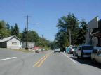
In a stretch of flatland between the Nisqually River, a few shops, houses and cabins lining the highway make up the town of Ashford. Forests cover the surrounding Nisqually Valley except for a few meadows and fields. The Nisqually River flows through a wide boulder-strewn channel a mile south of the town. Heavy snow melting in the spring frequently floods the channel and litters it with rocks dredged out of the mountain slopes. Just to the north, the mountain slopes rise abruptly, forested thickly in evergreen trees.
Just a few miles to the east is the entrance to Mount Rainier National Park. From the south side of the Nisqually Valley, the glacier-covered peak of Mount Rainier can be seen towering spectacularly over the valley and the surrounding forested mountains, which hide it, however, from the view in Ashford itself.
As of the year 2000, there were 267 people living at Ashford. A cluster of shops at the center of town cater to visitors to Mount Rainier, along with a few lodges and motels. It sits at 1800 feet in elevation, a full 12,500 feet lower than the nearby peak. Thick, green forests surround it in every direction, with a variety of scenic drives to choose from.
For More Information:
See Wikipedia's Ashford article.
Street Index
|
Mount Tahoma Road State Highway 706 |